The sun came out yesterday afternoon, hallelujah! I went out and took some pics with the OM-5. Nothing spectacular, because I just walked around the house.
But around dinner, I recalled I'd gotten a text from Spot the Station, that the ISS would be overhead that night. (Often, I forget these things unless I create a reminder. Most often, it's too cloudy to get a shot.)
I thought I'd try something different and use the MEIKE 3.5mm/f2.8 circular fisheye. It's kind of a gimmick lens in that it covers a 220° diagonal, meaning it's nearly impossible to keep yourself out of the frame. (It can see behind itself a little.)
Because I figured I'd forget between when I remembered and when it appeared, I set a timer on my watch and went ahead and set up the tripod before sunset. The ISS would be visible an hour after sunset. I also put the MEIKE on the E-M1 Mk3, which usually does star trail Live Composite duty for me.
About 15 minutes before it was to appear, I mounted the camera on the tripod, checked to see if the focusing ring was at infinity, the aperture was fully open and the camera was pointed directly overhead. I should have bumped up the exposure because the MEIKE is a little more than stop slower than the mZuiko 8mm/f1.8, but the ISS Is pretty damn bright so I knew I wouldn't miss it. Wasn't sure how the stars would turn out.
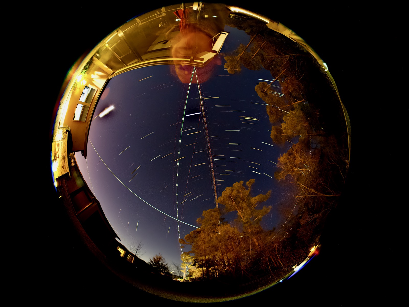
I pressed the shutter and hoped for the best. The result is above.
This is the text you get from Spot the Station:
Time: Sun Jan 14 6:57 PM, Visible: 5 min, Max Height: 44 degrees, Appears: WSW, Disappears: NNE
Looking at the image above, south is at the top of the frame, where my giant head appears. The ISS track is in the lower left quadrant. It appeared at the left edge of the frame, near the 3:00 o'clock position, just below the crescent moon. Max "height" appears a bit less that 44° because we're looking at 220° of coverage, so 110° to zenith from the edge of the frame. It tracks north-northeast, away from my giant head, and disappears in the trees northeast of the house.
The usual north-south commercial air traffic is visible in the frame, along with a few other aircraft. This is about a 30 minute "exposure" or perhaps, "integration" time.
If I do this again, and I probably will, I'll think about putting the top of the camera pointing to the north, so the image isn't "upside down."
Originally posted at Nice Marmot 06:38 Monday, 15 January 2024